Showing posts with label Geology. Show all posts

Sunday, December 19, 2010

To Death Valley or Not to Death Valley

Warning: not amateur science. This one is more like, what I did this weekend for fun.

Recently we made the move from Idaho to Nevada. Part of the tradeoff from the move included the ability to drive from the relatively high elevation cold temperature basin and range country to the lowest spot in the country, Death Valley, within a few hours. As the forecast for this weekend included snow at the new home in Nevada, I thought to take advantage of the nice weather I expected at -200 ft elevation of Standpipe Wells.


The drive from our neck of the woods to Death Valley involves a relatively uneventful trip south through Tonopah and then Beatty Nevada. This is the southern edge of the Nevada basin and range where the topography makes the transition to more subdued alluvial fill basins separating widely spaced mountains. The total elevation drop is something like 6700 feet in a three and a half hour drive. The majority of the drop is in the final thirty miles out of Beatty and down the mountain range into Death Valley. My ears popped the entire way down.

Yawning and chewing gum on the Daylight Pass road into Death Valley, the basin opens up with a wide view of Standpipe Wells to the southwest and Furnace Creek to the south. The mountains to each side are rich in complex structural geology, including on peak to the north that is suffuciently faulted to be called Corkscrew Peak. The road comes over the pass onto a steep alluvial fan, maybe a six percent grade. Large boulders litter the slope at the top of the fan and grades to smaller and smaller rock as you drive toward the valley basin. Occasional monolithic outcrops emerge from the smooth alluvial fan, very out of place blocks rotating out from the faulted basin fringes. The driver slows down to a turtles pace to navigate the road placed in a channel eroded from just such a block called Mud Canyon.

The road makes an unnecessarily complex set of turns that allows you to head north to Scotty's castle, south to Furnace creek or continue west to Stovepipe Wells.

Stovepipe Wells is a little outpost composed of a motel, gas station, campground and ranger station. The last time we visited, we stayed the night at the motel. As with any national park hotel it was insanely overpriced and provide an adequate living space. In late October, when the rest of the country is facing the pre-Halloween blizzard, Stovepipe Wells is the perfect temperature. There is little better than waking up at seven am to find the sun edging over the surrounding mountains casting the entire valley in the soft glow of the dawn magic hour.

Right down the road there is a dirt road forging up the alluvial fan to the south toward the base of the towering Tucki Mountain. The gravel parking lot at the top of the road is at the outlet of Mosaic Canyon. When I visited there was blue skies with a hint of black storm cloud sending feelers over the top of the mountain and a whole parking lot full of cars. Now Mosaic Canyon is one of those amazing little features that funnels an entire mountain range's worth of runoff through a two foot wide and twenty foot deep canyon...maybe once or twice a year when the rain comes. My concern at the time was that the rain clouds that were ominously rumbling up at the peak of the mountain were preparing to send a wave of water, trees, rocks and tourists down the trail at me.


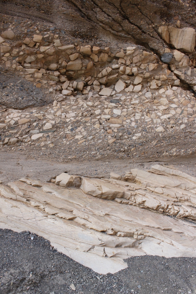
The geology of the canyon was great. The reason folks go to Mosaic Canyon is because of the butter smooth marble walls of the lower canyon. The marble is truly beautiful with alternating bands of orange, cream, and dark brown - if it weren't in a national park, they would be making counters from the stuff. The periodic water and gravel abrasions scalloped and ground the marble to the point where it became "soft" as a youngster exclaimed as he slid down one of the walls. The good stuff was all within a quarter mile of the parking lot.


The marble is not the only interesting geology. There was a fine grained matrix supported coarse, angular clast conglomerate that could be found at the upper contact of the marble, although it could also have been lithified alluvium or possibly volcanoclastic. Large pumice boulders were occasionally sticking out of the canyon wall above the marble. Higher up the canyon mineralized ironstones and quartz laden metasedimentary rocks litterered the canyon floor. The slopes lining the canyon walls were red metasedimentary rocks and looked mineralized but I did not see evidence of mining. The canyon became unaccessible about a mile up from the parking lot at a steep cliff that would have been a challenge to free climb.


The next destination was to find a camp site and maybe check out some of the old mining that happened at Death Valley. Continuing on the road going west from Standpipe Wells, the highway skirts an alluvial fan gaining elevation quickly until it is a bit above two thousand feet at Emigrant, a campground and rest stop. From there, take the Emmigrant Canyon Road and follow it, gaining elevation the entire way. At one point the foundation of an old mill appears on the south side of the road and the gravel road to Skidoo is about a mile later.

The gravel road to Skidoo is a winding, clothes washed rutted, and occasionally blasted from a sheer cliff face. A few miles from the road entrance the telltale piles of rock betray the presence of mining. Some of the infrastructure has even been preserved by the park staff. This small head frame still has the sixty foot shaft is still open and timber supported with a serviceable ladder. The entrance itself had been blocked by a cable mesh rock bolted to the shaft walls.


A number of exploration holes were present and curiously followed a outcrop of a quartz vein in the granite bedrock. A little shack was built on the other side of the valley. The mineralization I could find in the piles were open vein fill crystals of some white mineral that had a botryoidal habit. There were small yellow sulfide crystals mixed in, possibly pyrite or tetrahedrite and a dark accessory mineral in the white quartz veins. It looked a lot like the gold vein I found with a metal detctor in Quartzite a few years back.

Continuing down the road, I discovered the town of Skidoo, an old mining town at the top of the world above the Death Valley. There was a sign marking the site and hundreds of mine workings in the surrounding hills. All the buildings had been removed and there was no visible evidence that the place had once been home to dozens of large buildings less than one hundred years ago. The sign did have a few black and white pictures of the valley from the the towns heyday. Investigation of the quite large workings in the granite nearby showed backfilled trenches or gated adits.

Here is a nice one pager website on Skidoo.

I ended up camping nearby that was certainly not in the posted "Day use only: No camping" area. I set up our large family tent on a roughly flat area before the looming clouds and dark arrived. Between the elevation and oncoming storm it became quite cold. Despite the four season tent and Idaho-class cold weather gear I ended up having a bad night. The wind blew the tent down, although to be fair, the water stayed mostly outside.

When the sun finally came over the horizon it was still raining and gusty. I managed to stuff the sleeping gear and muddy tent into the back of the jeep and get off the mountain before the rain turned to snow. The bad weather really put a damper on the plan to hike out to some of the more remote mine workings.

On the way out I snapped a picture of the Mesquite Flats Sand Dunes during the rain and it can be compared to the picture I took a few months ago when the weather was ideal.

Normal


With Rain

Death Valley is a great place when the weather is nice. I hope to get back there one of these upcoming weekends when the weather improves but before it gets too hot later this spring. I love the idea of being able to drive out of the bad weather. It didn't work out this time but I am hopefull that it will work sometime in the future.

Friday, December 3, 2010

The Great Meteorite Hunt Debacle

Meteorite hunting can be a cruel mistress. Last week I was travelling through Austin Nevada during a trip to my new place of employment. I was a little early to check in at the hotel and decided to visit a nearby playa basin to hunt for meteorites. I was also testing the hypothesis that meteorites could be found nearly anywhere rocks are uncommon and easy to find – salt flat…which was bolstered earlier by reviewing the Meteoritical society’s database of known meteorite find locations.  

Google map of the Meteoritical Society's database of meteorite finds.

A front had moved through and there was a fresh coat of snow on the ground a few inches deep. Clouds were boiling on the edge of the basin and zero-visibility blizzards came through more than once that afternoon.  I turned off the gravel road and took the truck down the muddy alluvial fan towards the salt flat. After a fun 270 degree spin, I parked and started hiking. Looking around the valley, the salt flat was surrounded by mountains composed of metamorphic and basalt rocks.  

Google map of Nevada salt flat

The snow was deep enough to cover most of the ground, but any of the small bushes or scrub had a bare spot at the base. As I walked I noticed that there were no rocks to be found. I must have walked two miles without seeing a single hard rock. Any mud balls or sticks that I came across were sticking up through the snow and transmitted enough ground warmth to melt a bare spot. I figured that if there was a meteorite (or random rock) I would have seen it.

Salt flat

And of course I eventually ran across a couple of tires, thousands of mudballs and sticks, and one rock! I got very excited and immediately picked it up for a look. It was about the size of two baseballs, a greenish colored exterior with red and yellow-greenish mottling and dark veins on the exposed interior. There was also a clearly visible rim on the edge. There are a lot of reasons to think this was a meteorite! Here is a website that describes rocks a lot like mine. 


The coloring of the interior is similar to other weathered meteorites I have seen. The reddish color is rusted iron and the green comes from olivine or chondrules. The visible rim was similar to the alteration associated with a fusion crust developed as the meteorite hurtles through the atmosphere and melts the outer surface. If these characteristics were true, it would be consistent with an LL type ordinary chondrite, the most common type of meteorite found.

Figure 1 - Weathering Rim

Figure 2 - Exposed interior top-left, exterior bottom-right.

Figure 3 - Mottling and veins

Closer inspection of the rock convinced me that the rock was not a meteorite. The greenish color of the exterior is very unusual for an ordinary chondrite. The rim on the edge looks a lot more like a weathering rind than a fusion crust. Fusion crusts are typically black and thin. Weathering rinds occur because a rock travels a long way and is exposed to the atmosphere and water that break down the minerals on the outside of the rock. You might expect the crazy random rock that survived the trip all the way down the hill to have a little extra weathering. Finally, the mottling could also be explained by the hematite and plagioclase or olivine that are found in basalt, a rock that could be found uphill. Meteorites can have veins, but terrestrial rocks are a whole lot more likely to have them.

There is one final test. In all honesty, as I type these words I have not yet taken a magnet to this rock. If the rock does have metal in it, the magnet will be strongly attracted to it. The red hematite is an oxide of magnetite, which is also metallic, and could also attract a magnet. However, the strength of the attraction should be easy to tell the difference. Ok, here goes. Nope, not magnetic.

Alright, that’s the test. Its not a meteorite. Meteorite identification is not for everyone, but I like the process. If it had been a meteorite as far as I could tell, the next step to confirming it as a meteorite is to send a portion of it to the closest geology department with a meteorite specialist. At Arizona State University, this would be the ASU Center for Meteorite Studies. http://meteorites.asu.edu/ Once there, a specialist would look at it, considering the mineralogy and structure of the rock. If it passes, the specialist will use an instrument called the PIXE, Particle Induced X ray Emission spectrometer, will be used as the final test to determine if the iron to nickel ratios are consistent with a meteorite. At that point, you then have a real meteorite!
          

Monday, November 22, 2010

Muon Telescopes...Attack! Part I

The last time I was in Rapid City I got a chance to visit my friend's physics lab at SDSM&T. Mark Hanhardt showed me his work detecting incoming particles generated from cosmic ray interactions with the atmosphere. He does this with an uber-sensitive photomultiplier tube that can measure individual photons. When I was there, I noted the suspicious absense of duct tape. That is simultaneously comforting and disturbing as his work will eventually become part of the research lab at the Deep Underground Science and Engineering Lab at the Sanford Homestake Laboratory in Lead, SD.


Mark's Lab - Note how time and space are visibly distorted there. Two photomultiplier tubes are visible on the left, middle - they are the gold colored glass bulbs with grey bases in the box. 

Mark, the FLOEAS resident particle physicist, had a response to the DUSEL muon flux shielding questions that came up a while back:


I have two notes about the work you did to calculate the mwe: First of all, I may have just been really tired when I read one of your calculation emails, but I don't think that comparing the relative densities of different types of rock to water will work.  I'm probably overthinking this, but when we are talking about muons, we are talking about charged particles, so it's not just the mass of the barrier, but also the charge distribution, structural lattice, and other atomic considerations. Then again, as I type that out, I think those things may smooth out enough over large distances that maybe my objection is moot.  Anyway, my second note would be this: I think that the muon rate is so easy to measure empirically that it's entirely possible that when people do mwe estimates, they simply let it be equal to some close, round value of the depth of rock (adjusted by experience) until someone actually measures it with a muon telescope or other apparatus to update the estimate. 


Yes, muon flux can be measured directionally.  I have been so focused on trying to finish my PMT work, that I have had no time to study the muon telescope I will be installing at Sanford Lab in January, but as I understand the proposed design it will primarily consist of two separate scintillation/PMT devices placed tens of meters apart in the line in which we expect the muons to travel.  (The underlying concept is that a muon is confirmed detected when we get a coincident signal in both detectors.)  As such, I expect that by placing these two devices along different lines we can measure muons incident from a different direction.  Given good enough time resolution, I also believe I can tell if the muon is traveling parallel or antiparallel to my device-line, although it's something I don't think my professor has considered since we will probably just assume that the bulk of the muons are traveling downward.


Mark is a great guy. I hope he finishes his physics degree, because he is my friend and not because of the monster it will make him. Only getting a PhD and becoming a tenured professor could make his ego any bigger, but his belligerence is boundless.

So, scintillators and photomultiplier tubes are arranged to detect incoming muons. The scintillators are pieces of plastic that emit a flash of light when struck by ionized particles, such as muons. The flash of light is detected by the  photomultiplier tube, converted to an electrical pulse, and amplified hugely to a voltage that can be measured by an oscilloscope. There are two sets of these scintillator/PMTs separated by some distance, tens of meters as Mark says. When an incoming particle strikes both scintillators (nearly simultaneously), scientists know it is a muon as opposed to some other type of radiation - say, decaying thorium in the nearby rocks which would only strike one scintillator. This apparatus is called...wait for it...a muon telescope!

Mark is saying that if one were to place two sets of these detectors at right angles, you could tell the difference between cosmic rays incoming from the atmosphere and random flux. This would help answer my question about heterogeneous muon flux because of changes in topography or overlying geology. The only catch is you would have to rotate this big, 30+ foot long apparatus inside a relatively small underground cavern long enough to gather enough muon measurements. I would even argue that the perpendicular apparatus is not necessary to measure flux.

That's it for this one. I have a bunch of detailed questions about how this stuff works and attempt to answer it in the next post, Part II.

Sunday, November 21, 2010

Bacteria in Deep Rocks, but not really Deep Rocks


www.newscientist.com
An expedition to the deepest layer of the Earth's oceanic crust has revealed an ecosystem living over a kilometre beneath our feet


Bacteria were found in a deep drill hole where life was not expected. Now Sam sent this to me and I think I read the abstract that day too. This guy Sam does some kind of computery work and he rides a bike, but he definately has a sensitive science antenna because it clearly quivered enough for him to recognize that this is a potentially important article.

The idea of microscopic life surviving, and even thriving, in pore spaces or tiny fractures deep underground is not new. Dr. Tom Kieft has been doing this for some time (http://infohost.nmt.edu/~biology/people/faculty/t_kieft/research.html) and his group has been going much deeper than the New Scientist story. The difference is that Dr. Kieft has started at the bottom of deep mines in South Africa (with plans to do similar studies at DUSEL in South Dakota) and drilling down to access even deeper depths. The depths his group could theoretically reach with the infrastructure of DUSEL make the New Scientist study look like they just scratched the surface...and they expect life as far as they can drill. 

So, what's the big deal? They say in the article that they didn't expect to find life in this Gabbro layer, which is right above the mantle. However, careful study of the little cartoon shows that they just hit the very top of the gabbro layer. The substantive difference between the basalt and the gabbro is minimal. There is a relatively small geochemical difference and the crystals are bigger. Both will possess very similar porosities and minerals that the bugs can use to survive. I think as long as the temperatures are low enough to allow proteins to function, there is sufficient chemistry for microbiota to process, and water, you will find life in earth. And life seems to find ways to push the limits of temperature, chemistry, and water that we think will allow them to survive. 


There was one little gem that they mentioned but did not elaborate. They only found bacteria, but no Archaea. Now Archaea are a type of single celled microscopic bug that look, smell and taste just like bacteria, which is why they were not included in the textbooks until recently. For example, Archaea are not to be found in my high school text books. But recent advances in cell culturing, genetic sampling of ground up DNA, and a phylogenetic analysis indicate that Archea are distinct from bacteria and our branch of the tree, eukarotes. Archaea are typically known as the extremophiles that have the ability to live in super-high temperatures or chemical environments that kill off all the other types of life. They also do a lot of interesting geochemistry that allows them to not only survive, but use poisonous gasses and chemicals to gain energy. 

Why, why, why are Archaea not present in the basalt layer? What kind of genetic advantage do bacteria have that allow them to live so deep? Is it possible that the Archaea simply were not detected? The authors do include a hypothesis that the bacteria migrated from oil reserves. But is it reasonable that bacteria would go from a very high hydrocarbon environment to a very sparse hydrocarbon environment? Why would Archaea not be capable of making the same evolutionary step? 

Understanding the evolution of microscopic single celled life on earth is important because it holds the spot at the root of our tree of life. You could also imagine that better understanding the conditions that these critters live and evolve under will be helpful when we investigate other planets, like Mars and Europa, for life. And that is exciting. I think there are some big holes in this particular story that are open to the researcher community. It will be interesting following this story over the next few years.

Friday, November 19, 2010

Love me some meteorites

One of my passions in life is meteorites. It is amazing that little pieces of rock can fall through the sky and land mostly unharmed on the surface of the earth, after four and a half billion years circling the sun. There are numerous myths and misunderstandings about meteorites (a popular term is meteorwrongs in the professional meteorite world). But the geochemistry of a handful of meteorites have told us more about the composition of the solar system than all of the robotic probes sent out combined. 

One of the meteorite hunter pioneers, H.H. Nininger, laid out the strategy for hunting meteorites. All things being equal, meteorites can fall anywhere on the planet's surface and the location of strewnfields is completely random. The only thing you can do to improve your odds of finding a meteorite is to find places where meteorites will be preserved, exposed close to the surface, and relatively easy to find. So, he said, look in places where there are not rocks, the ground is slowly eroding away, and where the ground will contrast with meteorites so they are easy to find. Places like Kansas and the saharan desert are ideal. 

My Mom and stepfather, Ron, have been spending their time for the past few years snowbirding in the south looking for gold nuggets with a metal detector. The by-product of their pursuit often includes finding little bits of wire, foil, bullets, and...meteorites. Aside from the handful of meteorites I have purchased, the ones they sent me from Gold Basin and at least one other location are the only sizeable meteorites I own. It is my hope to someday find one myself, but I have not had the luck, location, or time to track one down. 

Hopefully all this will change soon. When we make the move to Nevada we will be entering the land of desolate alkaline basins and slowly eroding deserts that are ideal for preserving and exposing meteorites. There are many places that meet Nininger's criteria. I look forward to the chance to take a weekend and go find a ten kilo meteorite. 

So, how do you evaluate where to find a meteorite? Well, Nininger also said that meteorites are where you find them. There is no place in particular on the planet to find more meteorites, but meteorites that break apart during their fall tend to end up on the ground in an ellipse called a strewnfield. If you find one meteorite, odds are there are a number of other meteorites from the same rock that are scattered about the area. One tool that a person can use to find strewnfields or individual meteorites is the database from the Meteoritical Society. Public information is available from the Lunar and Planetary Institute website, http://www.lpi.usra.edu/meteor/ There are nearly 40,000 individual meteorites registered in their database. After doing a search and narrowing down your results to a state or region, the results can be plotted on google maps with labels. This is the tool I plan on using to identify a location to hunt for meteorites. 


One thing that I notice is that the large majority of the meteorites found in Nevada are in the alkaline salt flats found in the basin. Some of them are in clusters, like Bluewing and others are individuals, like Alkali. Another interesting idea is that there are many more meteorite finds reported close to Reno and Las Vegas - because these localities are easy to get to, presumably? Our new home is going to be nearly as far away from a big city as possible and nearby a salt flat. Additionally, some of the individual meteorites that could very well be part of a strewnfield are in salt flats that can be found within a few hours drive. All in all, I think we have a pretty good chance of finding one if we can approach the localities with enough time and effort to give it a good try.

Thursday, November 18, 2010

Cave Enlargement Pills - No RX-Required to Order

Just the other day Elizabeth and I were watching a documentary about early man, something on the order of a million years old. The archeologists were excavating a cave in Spain and finding neolithic skeletons at the bottom of a pit. The part that caught both of our attention was that the pit was at the bottom of the cave, a 45 minute crawl. It was the kind of location that neolithic man would not have managed to reach let alone gone and died in. The documentary ended by suggesting that the pit was originally open to the ground and the neolithic men were dumping bodies into the pit as a form of early burial. 

The implication is that so much deposition occurred in the intervening years that a hillside was placed and a cave opened up to allow underground access to the pit. All this in a million years. 

Sure, as a geologist, I like to think I have a pretty good sense of time and scale. After all, a 200 foot deposit only needs 0.0024 inches/year over a million years. This is a dust film. The hard part is imagining a deposit that could remain stable and also form a cave. Caves are typically limestone, which only forms under water, usually deep water. That does not make a whole lot of sense in this case. 

This paper is interesting because it suggests that cave formation is more dynamic than many geologists would expect. The waters that carve away at underground openings can also slowly fill in those cracks and deposit material. The point I took from the paper is that the chemistry of the water is crucial. If the water is not saturated in carbonate, limestone will more easily be dissolved. 

Does the paper explain how neolithic man was able to bury their comrades? No, the geology of that excavation seems very interesting and I suspect that the documentary makers made a mistake or the scientists were taking liberties about their interpretation.


gsabulletin.gsapubs.org
Most conceptual models of epigenic conduit development assume that conduits sourcing karst springs form as water that is undersaturated with respect to carbonate minerals flows from recharge to discharge points. This process is not possible in springs fed by

Say that ten times fast

It takes a very special kind of geologist to appreciate this paper. I like it because of the title's alliteration and potential lyrics for a drinking song. The paper no doubt makes some very important conclusions about ophiolites, obduction, and orogenies. 


gsabulletin.gsapubs.org
This study addresses the timing and pressure-temperature (P-T) conditions of ophiolite obduction, one of the proposed causes of the ca. 470 Ma Grampian orogeny of Scotland and Ireland. This event gave rise to the main structural and metamorphic characteristics of the Grampian te

We must not allow an REE gap! - Part II

This news article is juicy, and it makes me scratch my head - the Molycorp guy is saying counter-intuitive things about the market that will not necessarily improve the company's standing. 

Question: If the industry that utilizes REEs is nearly entirely outside the country (electronics companies are mostly based in eastern asian countries), does it matter if the huge majority of the REE mines are outside the US? Based on this line of reasoning, it seems that the geopolitics between Malaysia or Taiwan and China is more crucial than the US and China.


Update: Ok, re-reading. He does say that China is reducing export quotas and that his company is starting a new mine and expects to produce at a lower cost. The rhetoric banter was slightly hidden by a clumsy reporter and a dislexic reader.

We must not allow an REE gap!

This is a somewhat interesting article about Rare Earth Elements on Geology.com. The part about how crucial rare earths are in common items like rechargeable batteries is not detailed. I think that is a key detail because the trend to use batteries and other rare earth bearing technology is going to increase dramatically in the next decade. 

One story that comes to mind is about Molycorp at Mountain Pass, CA. I spent parts of a few summers across the highway fooling around in the Mojave high desert. Molycorp is one of the few economic rare earth mining companies in the US. They were shut down around the end of the time I was there. 

Everything I heard about why the mine was shut down were rumors mostly from miners that wandered in to camp from the desert. The story was that the operation killed a number of endangered desert tortoises, a serious offense in liberal California. The result was that the mine was raided by federal SWAT and shut down, a bit overkill, even for that state. The conspiracy story I was told for the extreme shut down was because one of the Senators had an investment in a Chinese rare earths operation and that he strongly encouraged the action in order to reduce competition and line his pockets. 

What I know about the story is that at one point I visited while they were in Care and Maintenance mode (basically not producing), they have been actively exploring the region for similar deposits for the past twenty years, and I talked to their mine geologist well after the first closure, suggesting that they had some kind of production.

It is unclear to me if any of the conspiracies have a grain of truth at the juicy center, but if they did, it seems like a pretty damning failure of national security to allow our country to be dependent on a foreign country for the sake of some rich senator's pocketbook.

Variability


It amazes me how much variability exists in the natural world. Once I took a class where the subject was Mars - it was wraught with generalities, where one measurement was scaled up to the entire planet. For example, new spectral data that may have been consistent with acidic geochemistry was used to explain how the early oceans of Mars must have acid that dominated the geology. At one point I was forced to stand up and exclaim that Mars was a planet with the same area as the surface of Earth, surely the same kind of variability in geology we see here must exist on Mars, if to a reduced degree because of the lack of tectonics and pervasive water. 

The samle subject struck me on a much smaller scale when I was reviewing a SD DENR report on the Homestake Mine closure I remember from my work as a consultant for the state. You will recall that the mine was closed and allowed to flood. There was a huge effort to remove all the potentially water-contaminating materials from the mine to comply with the Clean Water act. Following that effort, consultants traveled throughout the open portion of the mine and collected water samples where they could. There was over 300 miles of tunnels below Lead as deep as 8,150 feet below a 3000 acre footprint. The volume of openings is approximately the same as one third of the volume of Pactola Reservoir. The locations that were sampled were much less extensive, but they did find a surprisingly large variation in their results.

The temperature of the water sampled varied from about 50 degrees F up to about 130 degrees F. This is not entirely surprising, since the lower levels are quite warm from geothermal heat and the upper levels have temperatures equilibrated with the regional average temperature of about 52 degrees F. 

The pH varied from 6.5, slightly acidic, to 8.5, moderately basic, with a clear mean at 8.0. While there is much more to be considered, these values are important regarding the acid mine drainage potential. If the mine began generating acid, then these pH values would go down dramatically. 

They also sampled for TDS, sulfur, and a suite of trace elements. 

One item that was not sampled in this report was dissolved oxygen. The general idea is that after time oxygen is depleted and the water becomes anoxic. I suspect that this would have a dramatic effect on the ultimate geochemistry of these waters and the biota that could survive at the bottom of a flooded 8000 foot deep mine. 

The ultimate geochemistry of the mine is now a moot point as the mine is currently being dewatered to these depths and the results can be inspected directly. My hope is that they are doing an adequate job describing the kind of variation they observe not only with the dewatering progress but also as time progresses across the entire accessible mine footprint.

Deep Underground Science and Engineering Lab - Topography Shielding Part III

The best way to calculate permutations for the endmember cases of muon flux at the DUSEL 8000 ft level campus. 

Best case: Say the entire depth of the lab is a full 8000 feet below the lowest ground surface. Also, assume that the rock is very dense Iron Formation with a specific gravity of 6.0. The calculation is simple, 8000ft of rock * 6.0 g/cc / 1g/cc water / 3.28 ft/m = 14,600 MWE, meters of water equivalent. This is more than double the estimated MWE.

Worst Case: Assume that the 8000 ft campus is actually 7000 feet below the ground surface because of topography. Also assume that mining methods of removed about 75% of the in-place rock and backfilled it with sand. This sand would be largely dewatered by gravity drain effects and have an air void volume of about 30%. Any water that remains trapped in the pores of the rock will increase the effective density, but we ignore that here. Finally, we could assume that the rock would be a granite-like composition with a specific gravity of about 2.85. The in-place rock would be 1,750 ft thick * 2.85 g/cc Qtz / 1 g/cc water / 3.28 ft/m = 1,520 MWE. The sand would have a thickness (7000 ft total depth-1750 ft in-situ depth)*(100%-30% sand volume) = 3675 rock in-place equivalent. The rock-in-place equivalent should have a similar specific gravity so: 3675 ft * 2.85 g/cc Qtz / 1 g/cc / 3.28 ft/m = 3190 MWE. The two values are additive so 3675 + 3190 = 6865 MWE. This is only slightly below the estimated 7000 MWE for the 8000 ft level. 

The best case scenario is more than double the published estimate for the MWE. This estimate is also likely a significant overestimate because the iron formation is not largely extensive around Homestake, it is some fraction of the total thickness of the rock over the 8000 ft level campus. 

The worst case scenario is close to the estimated value, suggesting that the DUSEL folks were being conservative. I can not imagine a case where the ground below Lead would not be actively caving in with a lower MWE (although it is subsiding). In the muon flux shielding world, more is always better, so I can confidently conclude that the the MWE shielding estimate is a good one and likely to prove more effective when the lower campus is built.

Deep Underground Science and Engineering Lab - Topography Shielding Part II

Meters of water equivalent, m.w.e. is the unit of shielding used to describe how much muon flux can be filtered by placing an underground lab at a certain depth. I did a calculation looking at the mwe reported for the DUSEL. DUSEL's main cavern will be placed at approximately 8,000 feet below ground surface and the mwe is reported as 7,200. With a little unit conversion mathemagic, the specific gravity that the scientists used was 2.95. The density of water is 1 gram per cubic centimeter and specific gravity is the factor of times more dense than water. So, the scientists that estimated the mwe for Homestake used some kind of logic that assumed the rock above the lab was 2.95 times the density of water. 

This is interesting for a few reasons. 1) The 2.95 is close to the average density of continental material, the kind of thing that a physicist would look up in a book. 2) The Homestake formation and the surrounding units are highly metamorphosed greenschists, quartzites, and iron formations. The specific gravity of these units, in place, is about 2.85 on the low end for relatively light quartzite up to 5 or 6 for heavy iron formation. The estimate for specific gravity may be low by a bit under a factor of 2. 3) The 8,000 foot depth is based on a mine coordinate system that has a zero elevation somewhere near the top of the open pit (the zero point was mined out when the Homestake company opened up the pit in the 1980s). Anyone who has been to Lead knows that those hills are as much as thousand feet high. The actual depth from the collar of the shaft is much different than the depth from the Kirk trailhead to the 8000 foot level. And 4) the mining method was vertical stope retreat where large blocks of material were mined away and then refilled with a sand slurry. This fill material could be a relatively large fraction of the material between the lab and the ground surface. All of these factors are sure to introduce uncertainty in the back of the envelope mwe calculation. 

Instead, I would suggest using the block model that Barrick trusted to the state to estimate mwe. The computer model includes all the geologic formations, known rock density from drill core, and accurate 3d locations of the drifts and ground surface. These parameters could be used to estimate the mwe for any location that was sampled with diamond drill holes or mined during Homestake's operational period. The alternative would be to characterize the muon flux by accessing the opened caverns and directly measuring the flux. A final option would be to measure the gravity at each level and use the results to determine the effective density of the ground between levels - this method would provide a better understanding of the backfill and dewatering which could change the density after geologic modelling was completed by Homestake. 

I think tomorrow I want to look at the permutations of the best and worst case scenario for specific gravity of the ground above the DUSEL caverns.

Deep Underground Science and Engineering Lab - Topography Shielding

There is a figure that the Deep Underground Science and Engineering Lab (DUSEL) guys were bandying about back when the NSF was making its initial decision on which underground facility would best suit an underground neutrino detection lab, maybe seven years ago. The figure showed Homestake mine was the deepest candidate with operational facilities at 8,000 feet below the ground surface. This was considered favorable because the deeper the lab was buried the more cosmic rays would be filtered out. This was good because those pesky cosmic rays interfered with the neutrino detectors (the neutrinos were not affected by the earth above). 

My question is how the topography of the ground and the density of the ground change the shielding properties of the earth above the neutrino lab? I know this work has been done already to some extent. I had a conversation with Bill Roggenthen who told me Wick Haxton at U. of Cal Berkely did the theoretical work and Nicolai Tolich at U of Washington looked at the topography issue. But I still don't think anyone has looked in detail at the properties of the rock surrounding the lab, which could impart a directional shielding effect. 

Talking to my friend Mark, who is helping with a little experiment called LUX at the DUSEL, he says the important thing to look for is how many Muons can be shielded with depth. I told him this would be a problem since I did not believe in Muons, but he insists they really exist. So, if anyone is interested, I want to look into the question and you are welcome to join me. It is work that is likely already done or could be tested in a few years when the lower levels of the lab are developed and the muon background is directly measured. But it is a fantastic question and probably will impart lots of edumacation in the process.

Chilean Miners Saved - A technical marvel!

How did they drill the hole that allowed the Chilean miners to escape? 

There are a couple different methods I can think of. The fundamental problem with drilling a deep hole down is how do you remove the chips of rock ground ahead of the bit from the hole? Usually drillers use some kind of media like water, heavy drilling mud or even high pressure air to float or blow the chips out. 

If there is a column of mud or water a few thousand feet high, the pressure on the escape cavern (which housed the miners) is tremendously high and could either flood the cavern with liquid or overpressure the tunnel if it broke through. My guess is that they calculated how far they could drill on water and then pumped the hole down and then dry drilled the remaining segment. This would be inefficient drilling but might be the easiest way to not kill the surviving miners. 

I'm also thinking that they drilled numerous holes to feed water and food to the guys trapped for 69 days. Smaller diameter holes are easier and faster to drill and I imagine they could have burned through bits and blew out chips in the rush to get that first hole sunk. I remember at the beginning they could only send a small video camera to communicate with the miners by recording messages. This suggests to me that the first hole was only a few inches in diameter.

I have not been following the news in detail and the story might be out there. It would be slick to get the story linked or get some expertise from my geo friends who have spent more time on a drill rig.

This is an amazing recovery story and I'm happy for the survivors. Props to the brave medics who went down first and presumably came up last.

Carbonates in magma


geology.gsapubs.org
Aragonite, as an inclusion in olivine from a leucitite lava flow, provides evidence for high-pressure crystallization and carbonatitic activity beneath the geophysical lithosphere in Calatrava, Spain. The aragonite occurs as a single crystal within olivine (...


Cool for 2 reasons. 1) The entire paper and all the conclusions about the upper mantle is based on analysis of one grain of olivine, probably less than a mm in diameter. 2) Aragonite can be a weathering product of olivine, I wonder if it is possible that the aragonite crystal is the result of some kind of phyllosilicate weathering reaction? Occams razor says that this paper has exagerated conclusions, but I am always amazed when a geologist predicts an economic deposit from one grain in a piece of core.